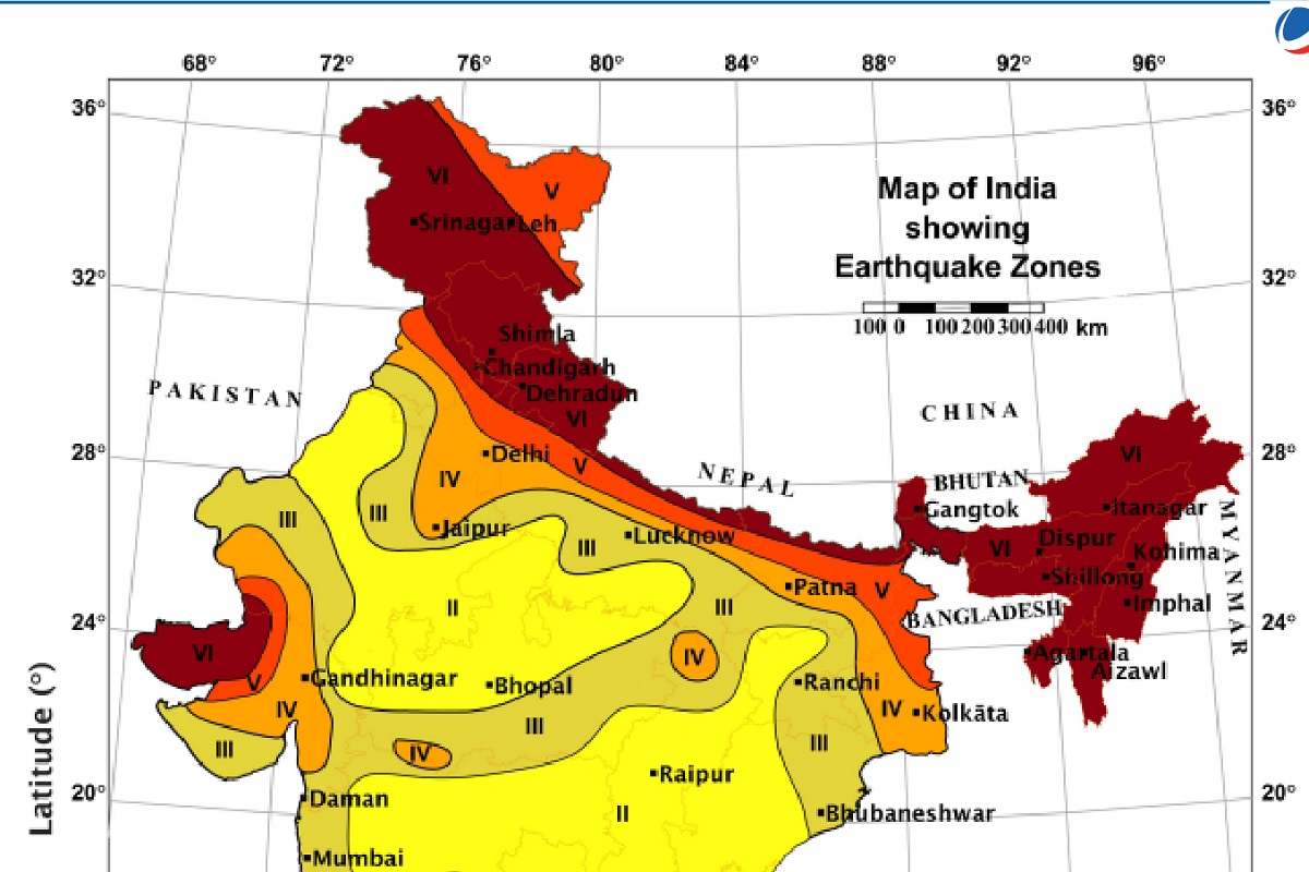
The entire Himalayan arc — including J&K and Ladakh — has been reclassified by the Bureau of Indian Standards (BIS) into Zone VI, the highest seismic-hazard zone under the updated 2025 national seismic map.
By: Javid Amin | 01 December 2025
What changed: From Old Zones to Zone VI
🔹 The Past — Zones II to V
Historically, India’s seismic-hazard map used four zones (II, III, IV, V). The Himalayan region — including J&K — was divided between Zones IV and V. But this zonation had limitations: it largely depended on past earthquakes, soil types, and broad damage-history, rather than detailed fault / ground-motion modelling.
That patchwork classification masked a deeper reality: the entire Himalayan arc lies along the collision boundary between the Indian and Eurasian tectonic plates — a zone of high tectonic stress, active fault systems, and long-term potential for major earthquakes.
🔹 The New Map (2025) — Enter Zone VI
With the 2025 update, BIS has introduced a new top category: Zone VI, effectively recognising what geologists have long warned about. Under this scheme:
-
The entire Himalayan arc — from J&K & Ladakh in the west to Arunachal Pradesh in the east — is uniformly placed in Zone VI.
-
Zonation is now based on probabilistic seismic hazard assessment (PSHA), incorporating detailed data on active faults, maximum probable earthquake magnitudes, ground-shaking attenuation, lithology (rock/soil types) and tectonic stress accumulation.
-
Areas located on boundaries between old zones are now automatically classified to the higher-risk category — eliminating “border-line” inconsistencies.
🔹 Broader Picture for India
The change is not limited to the mountains. With updated data and modelling:
-
Nearly 61% of India’s landmass is now in “moderate to high seismic hazard zones”.
-
A greater share of the population now resides in officially recognized seismically active zones, increasing the need for preparedness and resilient infrastructure.
In short: the update shifts from a reactive, historical understanding of earthquakes to a proactive, scientific-risk-based model — better aligned with geology and tectonic science.
Why J&K and the Himalayas Are Especially Vulnerable
🌍 Active Tectonics — The Indian-Eurasian Plate Collision
The Himalayas were formed by the ongoing collision of the Indian plate with the Eurasian plate — a geological interplay still active, pushing the mountains upward at roughly 5 cm per year.
Multiple major fault systems — including the Himalayan Frontal Thrust (HFT), Main Boundary Thrust (MBT), Main Central Thrust (MCT) and subsidiary faults — traverse the region. These are capable of generating high-magnitude earthquakes (Mw 7–8 or more), with strong ground shaking, landslides, liquefaction in sediments, and cascading risks to infrastructure, rivers and settlements.
⚠️ Locked Fault Segments — The Rising Danger
Scientists note that many fault segments in the central Himalayas have remained unruptured for centuries. Stress on these “locked segments” continues to build — significantly increasing the risk of a major future earthquake. The new map upgrades these segments to high hazard regardless of when the last quake occurred.
🔎 Ground Shaking, Liquefaction & Secondary Hazards
The updated hazard model factors in peak ground acceleration (PGA) — how hard the ground will shake — as well as soil type, ground response, slope instability, and liquefaction risk (soft sediments giving way during shaking). In hilly Himalayan terrain, earthquakes can trigger large-scale landslides, debris flows, flash floods — significantly amplifying the damage beyond just collapsed buildings.
All this makes J&K and adjoining regions among the most earthquake-prone in India — which the new classification finally recognises.
What Zone VI Means on the Ground — Implications for Infrastructure, Urban Planning & Society
🏗️ Stricter Building Norms and Earthquake-Resilient Construction
With Zone VI in force:
-
All new construction — residential, commercial, public buildings — must comply with the updated 2025 Earthquake Design Code. This includes strengthening structural frames, foundations, and design to withstand high ground accelerations.
-
Non-structural elements — parapets, overhead water tanks, facades, ceilings, suspended fixtures — must be securely anchored. These often cause injuries in earthquakes even if the main structure holds.
-
Buildings near active faults or soft soil zones require site-specific geological investigations (ground-response analysis, liquefaction risk assessment) before construction.
In effect, urban planning, building permits, audits, engineering oversight must become far more rigorous — especially in rapidly growing towns like Srinagar, Jammu, Anantnag, Baramulla, Leh.
🏥 Infrastructure & Critical Public Facilities — Hospitals, Schools, Bridges
Critical infrastructure — hospitals, schools, bridges, transport hubs, utilities — must be re-evaluated under the new risk framework. Retrofitting older buildings, especially those constructed before 2016, may become essential.
Emergency services will need stronger disaster-management plans:
-
Earthquake-resilient shelters
-
Stockpiling lifesaving equipment
-
Early-warning systems
-
Community evacuation plans
-
Regular drills
🌄 Rural & Hilly Settlements — New Challenges
Many villages in J&K and Ladakh are in remote mountainous zones — often built without formal oversight, using traditional materials. Under Zone VI, these settlements are officially recognised as high-risk zones.
This raises challenges:
-
Retrofitting stone or wood houses is costly
-
Building codes may be hard to enforce in remote belts
-
Awareness of seismic risk among residents may be low
-
Retaining traditional architecture while improving safety becomes a complex balancing act
🌐 Land-Use Planning, Urban Expansion & Tourism Infrastructure
With seismic risk redefined, policy-makers must reconsider:
-
Where to permit new construction — dangerous slopes, fault-line proximities, soft-sediment zones must be avoided.
-
Tourism infrastructure — hotels, resorts, cable-car lifts (in Gulmarg, Pahalgam, Sonamarg, Ladakh) need seismic-proof design.
-
Public utilities — water pipelines, power lines, communication towers — must meet resilience standards.
-
Emergency evacuation routes and solid communication plans for remote areas.
Why This Update Matters — Beyond Paper Zonation
✅ It’s About Reality, Not Assumptions
For decades, parts of the Himalayas were classified in lower seismic zones — simply because there was no record of a major recent earthquake there. The new map corrects that: it doesn’t wait for the next disaster — it anticipates it, using data-driven science.
⏳ It’s a Wake-up Call — Better to Build Preparedly Now
Every day, more homes are being built, more roads and bridges laid, more towns expanded. This update says: plan for the worst now — it’s not about waiting for a quake, but minimizing future loss of life and infrastructure damage.
🌿 It’s an Opportunity for Sustainable, Resilient Development
This is a chance to combine heritage architecture, climate-sensitive planning, and disaster resilience. Retrofitting traditional houses, designing quake-resilient public buildings, and ensuring safe urban expansion can protect communities — without sacrificing lifestyle.
🛡️ It Raises the Bar for Disaster Preparedness and Public Safety
From schools and hospitals to villages and resorts — everyone now must plan for seismic resilience. That means better building codes, early warnings, community awareness, disaster drills — a proactive shift rather than reactive panic after an event.
What Should Happen Next — A Roadmap for J&K and Himalayan States
Here’s a suggested blueprint for authorities, planners, and communities:
-
Immediate audit and retrofitting of old buildings — public & private — especially schools, hospitals, bridges, community centers.
-
Mandatory geological / geotechnical surveys before any new construction.
-
Public awareness campaigns — drills, school education, media communication, local-language outreach.
-
Updating local building by-laws to incorporate 2025 BIS Earthquake Design Code.
-
Seismic-safe zoning plans — avoid building on steep slopes, soft sediments, or near known fault lines.
-
Emergency response infrastructure — shelters, communication systems, rescue teams, resource stockpiles.
-
Regular monitoring of fault zones, landslide-prone belts, and hazard-mapping updates through modern scientific supervision.
What the Data Means — Understanding Risk, Not Panic
A few crucial clarifications:
-
Classification in Zone VI does not mean that a major earthquake is imminent. Rather, it means that the potential risk is high, and the region’s geology demands better preparedness and construction standards.
-
This update is based on hazard assessment, not a prediction of timing. Earthquakes remain unpredictable in terms of when they will strike.
-
The new map simply aligns hazard assessment with scientific understanding — acknowledging locked faults, tectonic stress, and ground-motion potential, even if surface ruptures haven’t occurred in centuries.
In simple words: this is a warning and an opportunity — to prepare, build resiliently, and reduce risks — not a reason to panic.
Conclusion — A Turning Point for Himalayan Disaster Risk Management
The 2025 seismic map update marks a historic shift for the Himalayan states — including Jammu & Kashmir and Ladakh. For the first time, seismic hazard assessment is unified across the entire mountain arc under a single highest-risk Zone VI.
This move — backed by modern PSHA science, ground-motion modelling, geological fault analysis — signals that the country is serious about aligning building norms, planning, and disaster management with geological reality.
For communities in J&K — urban and rural alike — this is a call to action. Not of fear, but of resilience. It is a chance to rebuild, retrofit, and plan smart for a future where mountains may shake, but lives and infrastructure remain strong.
If leveraged properly — with wise policies, public awareness, and responsible construction — this could mark the beginning of a safer, more resilient Himalayan civilisation.