IMD Forecasts Fresh Western Disturbance to Bring Snow, Rain to Jammu & Kashmir on Feb 1–2, 2026
By: Javid Amin | 27 January 2026
New Weather System Likely to Disrupt Travel, Raise Avalanche Risk and Affect Plains & High Altitude Areas
Western Disturbance Brings Fresh Weather Activity
The Meteorological Department (MeT) has forecast that a fresh Western Disturbance (WD) will influence the weather over Jammu & Kashmir on February 1–2, 2026, bringing renewed precipitation in the form of rain in lower reaches and snowfall in higher altitudes.
Western Disturbances are mid-latitude weather systems that typically track from the Mediterranean region into northwestern India during winter and are a dominant driver of snowfall and rainfall in the Himalayan region.
Forecast Overview: Feb 1–2, 2026
Timing
-
Start: Late night of February 1
-
Peak Activity: February 1–2
-
End: Gradual easing by February 3 (subject to change with real-time dynamics)
Expected Weather
-
Plains & Valleys: Light to moderate rain and isolated snow showers
-
Higher Altitudes: Moderate to heavy snowfall at elevations above ~2,000–2,500 m
The MeT advisory emphasizes that the intensity and distribution of precipitation could vary rapidly, especially over higher terrain and passes.
Regional Weather Breakdown & Risk Levels
| Region | Expected Weather | Risk Level |
|---|---|---|
| North Kashmir (Kupwara, Bandipora, Gurez) | Moderate to heavy snowfall | High |
| Central Kashmir (Srinagar, Budgam) | Light snow/rain mix | Moderate |
| South Kashmir (Anantnag, Shopian, Pulwama) | Snowfall and accumulation | High |
| Jammu Region | Rain showers | Moderate |
| Ladakh / Zojila Pass | Heavy snowfall, road closure risk | Very High |
Implications for Travel & Connectivity
Road Transport
-
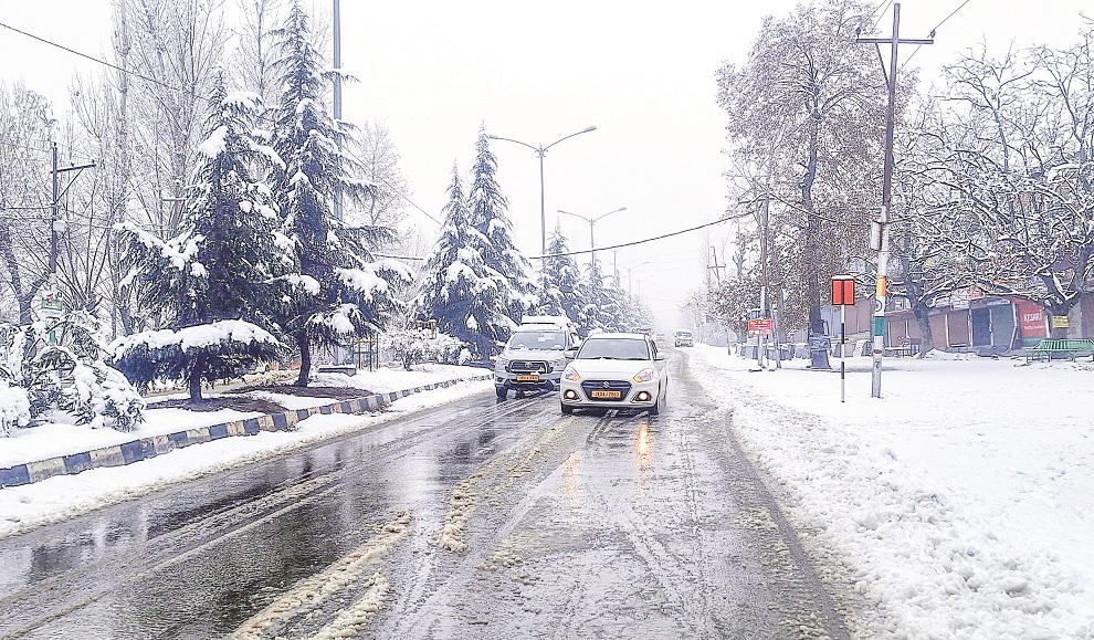
Srinagar–Jammu National Highway (NH-44): Snowfall and slippery patches could again disrupt movement on this vital link.
-
Mountain Passes: Routes including Zojila Pass, Mughal Road, and Sinthan Top may face temporary closures due to snow accumulation and avalanche danger.
-
Interior Roads: Local feeders and rural connectors may be temporarily blocked during peak snowfall.
Air Connectivity
-
Flight schedules at Srinagar International Airport may experience delays or cancellations if snowfall intensifies and visibility drops.
-
Travelers should check real-time flight status before departure.
Rail Services
-
Snow and ice near track sections (e.g., Banihal–Baramulla) may affect train operations — restoration depends on clearing conditions.
Avalanche and Safety Alerts
With moderate to heavy snowfall forecast in higher reaches, the avalanche danger increases significantly in:
-
Gurez
-
Kupwara highlands
-
Shopian and Pahalgam slopes
-
Zojila and surrounding passes
Residents, military personnel, tourists, and trekking groups are advised to avoid movement in avalanche-prone zones during peak activity and until official safety clearances are issued.
Impact on Tourism & Outdoor Activities
Popular winter destinations such as:
-
Gulmarg
-
Sonamarg
-
Pahalgam
are expected to receive fresh snow, enhancing scenic appeal but also restricting access and outdoor activity.
Visitors should:
-
Anticipate itinerary changes
-
Avoid venturing into isolated backcountry areas
-
Stay updated through official MeT and district advisories
Cautions & Preparedness: What Residents Should Do
Before the Event
-
Stock essential supplies: food, medicines, heating fuel/wood
-
Check housing safety: secure rooftops, drain off accumulations where possible
-
Keep emergency contacts ready: local disaster management, police, highway helplines
During the Active Spell
-
Avoid non-essential travel
-
Stay indoors during heavy precipitation
-
Monitor rapid weather updates from IMD bulletins
Why This Matters: Winter Vulnerability in J&K
Jammu & Kashmir’s winter weather has already:
-
Caused flight cancellations and travel disruption
-
Damaged infrastructure and housing in districts like Bandipora
-
Led to extended closures of NH-44
-
Triggered power outages across multiple regions
The forecasted WD on Feb 1–2 adds another wave of volatility to an already challenging winter season, particularly as the region continues to navigate Chillai Kalan’s concluding days of intense cold.
IMD Advisory in Summary
-
Date of Concern: February 1–2, 2026
-
System: Western Disturbance
-
Key Impacts: Snowfall, rain, travel disruption, avalanche risk
-
Precautions: Avoid travel, monitor updates, secure homes, check flight status
Takeaway
The approaching Western Disturbance is not merely another weather event but a continuation of a dynamic winter pattern that has repeatedly impacted life and connectivity in Kashmir this season. Residents, operators, and travelers are urged to plan flexibly, follow warnings closely, and prioritize safety as fresh rain and snow approach.