A Warning Resurfaced
By: Javid Amin | 28 October 2025
More than a decade after the devastating 2014 floods submerged much of Srinagar, the Jammu and Kashmir government has formally identified Jawahar Nagar, Kursoo Rajbagh, and Shivpora as flood-prone areas.
The official statement, issued during the Legislative Assembly’s Question Hour on October 28, 2025, acknowledged that these neighbourhoods—located on the left bank of the River Jhelum—remain acutely vulnerable whenever the river’s discharge crosses 40,000 cusecs. The declaration extends to adjacent localities such as Lasjan, Gandbal, Soiteng, Vethpara, Padshahi Bagh, Sonawar, Batwara, and Rajbagh.
The recognition is both a technical classification and a moral acknowledgment: a decade after the catastrophe, Srinagar’s urban core still sits on a flood knife-edge.
Understanding the Geography: Why the Left Bank Suffers More
1. The Low-Lying Bowl of Srinagar
Srinagar’s topography is deceptively beautiful—and dangerously deceptive. The city rests in a shallow bowl, with the Jhelum meandering through it like a liquid spine. Areas on the left bank (Jawahar Nagar through Shivpora) sit several feet lower than the river’s right-bank neighborhoods such as Bemina and Qamarwari.
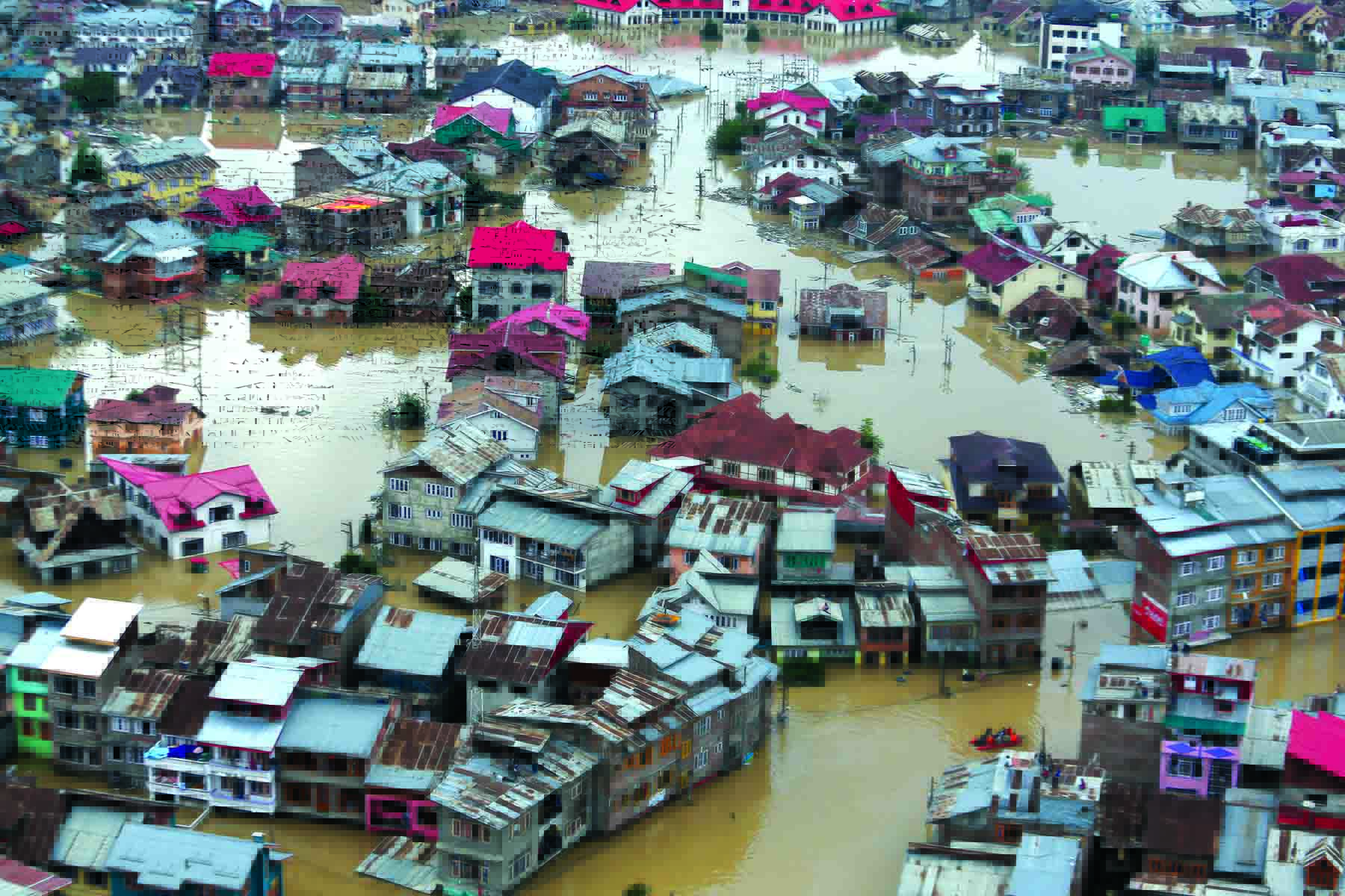
When the Jhelum swells, water naturally spills into these depressions. During the 2014 floods, Jawahar Nagar and Rajbagh were under 8–10 feet of water for nearly a week.
2. Choked Drainage & Encroachments
Urbanization has clogged the city’s natural drainage network—the Doodh Ganga, the Nallah Mar, and smaller channels. Many have been narrowed, encroached, or converted into roads. When heavy rain coincides with high Jhelum levels, the drainage has nowhere to discharge, turning entire colonies into temporary lakes.
Experts from the Flood & Irrigation Department note that over 30 percent of internal drains in the left-bank zones are silted or obstructed, worsening local inundation even during moderate rainfall.
The Government’s Admission: From Denial to Acknowledgment
For years, civil-society groups accused successive governments of downplaying Srinagar’s flood risk to avoid political embarrassment. The 2025 declaration represents a shift toward transparency—an official acknowledgment that the city’s most expensive real estate sits on a natural floodplain.
During the Assembly session, the government conceded that when the Jhelum’s discharge surpasses 40,000 cusecs at Ram Munshi Bagh, inundation in the listed localities becomes “inevitable without intervention.” This benchmark is critical for flood alerts and planning, aligning with Central Water Commission thresholds.
Mitigation Measures: What’s Being Done
₹15 Crore Immediate Works
The Jal Shakti Department has begun flood-protection projects worth ₹15 crore in Srinagar, focusing on:
-
Raising and strengthening embankments along Jawahar Nagar–Shivpora stretch.
-
Rehabilitating clogged storm drains and culverts.
-
Silt removal from critical sections of the Jhelum within city limits.
Officials say this is “short-term mitigation” while a larger master plan is finalized.
₹1,632 Crore Master Plan in the Pipeline
A comprehensive flood-management plan estimated at ₹1,632 crore is being prepared for the entire Valley. Key components include:
-
Deep de-silting and dredging of the Jhelum to restore its pre-2014 carrying capacity.
-
Expansion of the Flood Spill Channel from Padshahi Bagh to Wular Lake to handle peak discharges exceeding 60,000 cusecs.
-
Strengthening of embankments and bunds, particularly on the left bank.
-
Modern drainage pumping stations for urban pockets like Rajbagh and Sonawar.
-
Upgraded early-warning systems integrated with Doppler radar and real-time gauge monitoring.
The plan is awaiting final financial concurrence from the Union Ministry of Jal Shakti under the Flood Management and Border Areas Programme (FMBAP).
Lessons from 2014: Why These Areas Remain the Epicentre
The 2014 floods were not just a weather event—they were an urban-planning failure. More than 80 percent of inundated homes lay in the very localities now officially declared flood-prone.
Residents recall how floodwaters entered homes within hours as the Jhelum breached embankments near Padshahi Bagh and Lasjan. The current official list mirrors the 2014 flood map, underlining that little has changed on ground except awareness.
In Rajbagh, nearly 12,000 families suffered property loss exceeding ₹600 crore; in Shivpora, several multi-storey buildings collapsed due to prolonged submersion. The memory is etched in every household.
The Human Dimension: Life in the Floodplain
“Every Rain is a Reminder”
Locals describe living with chronic anxiety. Even a night of heavy rain triggers alarm messages in community groups.
“We sleep with our phones fully charged. The first thing we check at dawn is the Jhelum gauge reading,”
says Asif Hussain, a resident of Jawahar Nagar.
Insurance premiums are higher, property values fluctuate, and new buyers hesitate—yet construction continues unabated.
Encroachments Continue
Despite multiple demolition drives, encroachments on the riverbanks and flood channels persist. Several cooperative housing societies and private schools occupy reclaimed flood basins. Activists allege that weak enforcement and political pressure allow repeat violations.
Urban planners argue that without strict zoning laws and penalties, “flood-plain colonization” will undo even the best engineering interventions.
Science & Data: The Hydrological Reality
Hydrologists from the National Institute of Hydrology estimate that the carrying capacity of the Jhelum between Sangam and Wular has reduced by nearly 40 percent since 1980, primarily due to siltation and encroachment.
Current discharge thresholds:
-
Alert level: 25,000 cusecs at Ram Munshi Bagh
-
Danger level: 40,000 cusecs (city inundation risk)
-
Extreme flood: 55,000 cusecs (similar to 2014 event)
Climate projections indicate an increase in high-intensity rainfall events over the Kashmir Valley by 8–10 percent over the next two decades, which could further strain the system.
Governance & Policy Perspective
The New Approach
By formally designating flood-prone zones, the government creates a legal and administrative basis for:
-
Land-use restrictions in sensitive areas.
-
Targeted relief & rehabilitation protocols.
-
Prioritization of infrastructure spending.
-
Insurance and zoning compliance under the Srinagar Master Plan 2035.
It also aligns with the Sendai Framework for Disaster Risk Reduction—shifting from response to preparedness.
The Implementation Gap
However, experts caution that identification alone is not enough. Without empowered local bodies and transparent project execution, master plans risk remaining on paper. Flood-control projects in J&K have historically suffered from cost overruns, delays, and poor maintenance.
An internal audit by the Comptroller & Auditor General (CAG) in 2023 found that only 32 percent of earlier Phase-I Jhelum Restoration works were completed on schedule.
What Needs to Change
-
Urban Zoning Enforcement: Ban new construction within 200 metres of the riverbank and mark buffer zones clearly in land records.
-
Integrated Drainage Plan: Synchronize city storm-drains with the Jhelum’s outflow levels to prevent back-flow during high discharge.
-
Community-Based Warning Systems: Install sirens, SMS alerts, and ward-level disaster committees.
-
Maintenance, Not Just Projects: Regular desilting and embankment repair should be annual obligations, not crisis reactions.
-
Data Transparency: Real-time Jhelum water-level dashboards for public access can reduce panic and rumor cycles.
-
Climate-Smart Urban Design: Incentivize permeable pavements, green corridors, and rain-water harvesting to reduce surface runoff.
Voices from the Ground
“Floods aren’t just natural here—they’re political,”
remarks Dr Mehraj-ud-Din Shah, an environmental scientist at Kashmir University.
“Unless the master plan includes enforcement and citizen participation, the declaration will mean little.”
“We welcome the transparency,” says Nusrat Jan, a community volunteer from Shivpora.
“But we need relocation options, insurance, and local flood shelters before the next crisis hits.”
The Road Ahead: From Risk to Resilience
The government’s acknowledgment is a necessary first step toward resilience—but far from the last. The ₹1,632-crore plan, if executed on time with citizen oversight, can transform Srinagar’s relationship with the Jhelum from fearful coexistence to managed harmony.
Yet time is short. Climate models warn of increasing flood frequency, while urban expansion continues unchecked. Transparency must translate into tangible infrastructure, and community participation must accompany engineering solutions.
In essence, Srinagar must learn to live with water, not against it—through smarter design, stricter planning, and sustained political will.
Bottom-Line
The official designation of Jawahar Nagar, Kursoo Rajbagh, and Shivpora as flood-prone zones is more than bureaucratic housekeeping—it’s a wake-up call to rebuild a flood-resilient Srinagar.
Acknowledging vulnerability is the first act of resilience. The next is execution. Whether the government’s ₹1,632-crore blueprint becomes a safeguard or another shelved document will determine the city’s fate when the Jhelum rises again.
Until then, for thousands living along its banks, each dark cloud over the Pir Panjal remains both a source of rain—and a reminder.


