Experts pitch for preparedness to minimise damage, develop earthquake resilient society
By: Arif Shafi Wani
Frequent earthquakes in Jammu and Kashmir have set alarm bells ringing with experts calling for increasing preparedness level to minimise the loss of lives in case of high magnitude tremblors.
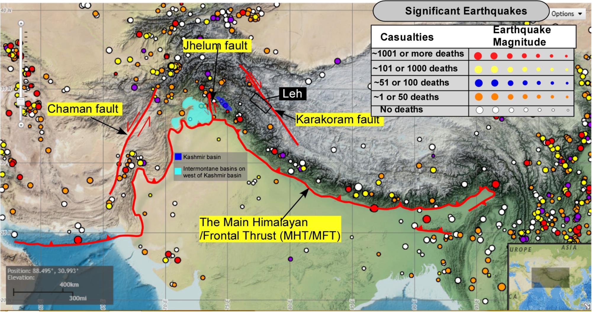
J&K falls under the high seismic Zones IV and V, making it vulnerable to earthquakes. A powerful 7.6 magnitude earthquake rattled J&K on October 8, 2005, claiming 1350 lives and causing massive destruction to structures.
For the past over a year, J&K has been witnessing frequent earthquakes including high magnitude ones. “We have to understand that the entire J&K falls in high seismic zones and is vulnerable to earthquakes. Though mild earthquakes in seismic zones is a normal phenomenon, we should worry as the magnitude of recent tremblors was high,” noted geologist Prof G M Bhat told.
“The problem is these tremblors can trigger major earthquakes in J&K, especially in hilly areas. There are high earthquake zones in Chenab Valley and Kashmir. We cannot avoid earthquakes but it is high time to develop an earthquake resilient society. We need to organise awareness programmes in schools, localities, and villages to prepare people for taking precautions during earthquakes. We have to learn to live with earthquakes,” he said.
On April 30 this year, an earthquake of magnitude 4.1 struck J&K. On May 8, a 3.1-magnitude earthquake jolted Kashmir with its epicenter in Baramulla district.
On June 13, an earthquake of 5.4 magnitude struck Chenab Valley, leaving three persons injured and causing extensive damage to over 23 schools and dozens of residential houses. On June 18, back-to-back tremors and aftershocks jolted Doda district.
Subsequently, an earthquake of 4.4 magnitude with epicentre in Bhaderwah town jolted the area. Within six hours another tremor measuring 4.1 was felt, sending the residents into panic. There were nine aftershocks in six days.
Experts, who have been monitoring the situation in J&K, are concerned over the increasing tectonic activity in quake vulnerable areas like Pir Panjal and Zankar range of mountains. Prominent geoscientist Abdul Majeed Butt also termed frequent earthquakes as “worrying.” “There is increased tectonic activity in the Pir Panjal and Zanskar range. These are indicators that a high magnitude quake can hit J&K, however, no timeframe can be given,” Butt told.
Butt, who has worked on various mining projects in Doda, said that the stability of the region geologically was highly fragile. “There is a need for consolidation. Plates have added up huge underground pressure which needs to vent and cause tremors,” he said.
Elaborating, Butt also blamed local factors for earthquakes and other disasters. “I am convinced of induced mechanical means which disturbed the core strength of our earth, causing such jerks with minor changes. Equally, I am convinced of the huge strength required by our core to strengthen the disturbed area,” he said.
Earlier this year, big cracks appeared in several houses in the mountainous Nai Basti area of Thathri in Doda district of Chenab Valley, creating panic among the residents. The situation was similar to Joshimath, a hilly town in north Indian state of Uttarakhand a few months ago where over 1000 houses cracked, crumbled, and caved in, rendering families homeless.
Doda has emerged as one of the most eco-fragile areas in J&K due to its unique geo-climatic conditions. It is prone to earthquakes and witnesses frequent low intensity quakes. Butt said that the situation was aggravating from the Mohimangat-Shopian axis across Pir Panjal and Sumcham Padder, Padam Zanskar besides the main axis of Doda-Kulgam periphery.
Uri, Bijhoma and Aharbal are on earthquake fault lines. “Earthquakes are literally beneath us. People of J&K must be mentally prepared for earthquakes. They should not construct structured buildings and instead use retrofit measurable. The need is to develop a strong response to ensure the safety of people during earthquakes,” Butt said.
Experts said the Chenab Valley, housing huge dams including Dul Hasti in Kishtwar and Baglihar in Ramban is vulnerable to earthquakes. The vulnerability of the geologically-young, unstable and fragile rocks in Doda have increased manifold due to various unscientific developmental activities. A study by a prominent US-based seismologist Roger Bilham has warned that Kashmir valley is likely to be hit by an earthquake of largest ever magnitude 9, but did not specify any timeframe.
Bilham, who carried out extensive studies in J&K has cautioned that the major quake with magnitude 9 is likely to trigger landslides that would dam the Jhelum River, which drains from the Kashmir valley into PoK.
“That could put Kashmir valley under water within three months – and would also threaten disastrous flooding in Pakistan if the waters were released too quickly. The two nations should develop a cooperative plan to deal with the aftermath of a Kashmir mega-quake,” Prof Bilham has stated in the study.
Prof Bilham had maintained that his Global Positioning System (GPS) data readings reveal that the gradual movement of rocks in the Zanskar mountains, north of the Kashmir Valley, show that earlier estimates of the maximum possible quake in the region were too low.
“In this region, the Indian plate is slowly burrowing under the Tibetan plateau. Studies on where the relative movement of the Tibetan plateau was slowest indicate where compression is building up, and a rupture is eventually likely to occur. I expected this to be in the Pir Panchal range, to the south of the Kashmir valley, but instead it was in the Zanskar range to the north,” his study revealed.
“This means that the zone likely to rupture when a quake eventually happens could be 200 km wide, rather than about 80 km, as was previously thought. The zone would encompass the Kashmir valley – including the city of Srinagar, home to some 1.5 million people. If slippage occurs over a length of 300 km, as is possible, a mega-quake of magnitude 9 is the likely result. Given building codes and population in the region, that could mean a death toll of 300,000 people,” the study states.
Prof Bilham, who has been studying the earthquakes in Himalayan region for the past 20 years, visited Kashmir in 2007. The Government of India is working to monitor seismic activities and identify high seismic risk zones in the Himalayan region to mitigate potential impacts.
In a written reply to Lok Sabha, Union Minister of State for Environment, Forest, and Climate Change, Ashwini Kumar Choubey on July 24 highlighted these efforts undertaken by the government to address seismic risks and protect the environment in the Himalayan region.
The National Centre for Seismology, under the Ministry of Earth Sciences, maintains round the clock monitoring of earthquake activity in and around the country, with a particular focus on the Himalayan regions, known for their high seismic potential. Amid rising frequency of natural calamities, the G20 nations under India’s presidency discussed disaster risk reduction in Chennai on July 24.
India, under its presidency of the Group of 20 nations, has constituted a first-of-its-kind Disaster Risk Reduction Working Group keeping in view the increasing frequency and severity of disasters that are wreaking havoc around the world.
In its Disaster Management Plan, the J&K government has recommended assessing the status of risk and vulnerability of the existing built environment, identification of safe zones. The authorities have also set up an Emergency Response Centre to start rescue and rehabilitation during natural disasters.