Jammu & Kashmir Weather Alert: Rain, Snow & Gusty Winds Expected from March 28 Night — Full Impact Analysis, Travel Advisory & Farming Guide
By: Javid Amin | 24 March 2026
A Turning Point in Kashmir’s Spring Weather
As spring slowly unfolds across Jammu & Kashmir, bringing with it blooming orchards and longer daylight hours, a fresh weather system is set to disrupt the calm. According to the India Meteorological Department through its regional office Meteorological Centre Srinagar, a significant spell of rain, snowfall in higher elevations, and gusty winds is expected to begin from the night of March 28, 2026.
For residents, travelers, and farmers alike, this is more than just a routine forecast—it marks a transitional phase in the region’s delicate spring climate, one that can influence livelihoods, mobility, and daily routines.
This comprehensive ground-informed feature breaks down the forecast, verifies the patterns against historical trends, and explains what it truly means on the ground.
Current Weather Pattern: Calm Before the Change (March 25–27)
For now, much of Jammu & Kashmir is experiencing relatively stable weather conditions. From March 25 to March 27, skies are expected to remain mostly dry, with intermittent sunshine and occasional cloud cover.
In practical terms, this means:
- Pleasant daytime temperatures, especially in plains like Jammu
- Cooler but comfortable conditions in the Kashmir Valley
- Limited precipitation, restricted to isolated higher-altitude zones
Ground observations from the Kashmir Valley suggest that daytime temperatures have been hovering in the mid-to-high 20s°C in some areas, slightly above seasonal averages. This mild warmth is typical during late March but often precedes a shift in atmospheric circulation.
Meteorologists attribute this stability to a temporary weakening of western disturbances—a weather phenomenon that plays a crucial role in North India’s precipitation patterns.
Understanding the Incoming Weather System
The upcoming weather change is linked to a fresh western disturbance, a system that originates in the Mediterranean region and travels eastward toward the Indian subcontinent.
In Jammu & Kashmir, such disturbances often bring:
- Rainfall in plains and valleys
- Snowfall in higher elevations
- Strong winds due to pressure gradients
Late March is a particularly sensitive period, as winter systems begin to weaken but can still carry enough moisture to trigger widespread precipitation.
This makes the March 28–30 window especially important.
Detailed Day-by-Day Weather Forecast
March 25–27: Mostly Dry, Mild Conditions
- Partly sunny skies dominate
- Minimal rainfall or snowfall
- Ideal conditions for travel and outdoor work
While isolated high-altitude regions may see light snow or drizzle, the overall pattern remains stable.
March 28 (Night): The Shift Begins
By the evening of March 28, cloud cover will begin to thicken across the region.
Key Developments
- Light rain showers expected overnight
- Precipitation probability around 71%
- Gusty winds likely to intensify
Residents may notice a drop in temperature and increasing wind speeds after sunset—classic signs of an approaching disturbance.
March 29–30: Peak Weather Activity
This is the most critical phase of the forecast.
What to Expect
- Widespread rainfall across valleys
- Light snowfall in higher reaches such as Gulmarg, Sonamarg, and parts of Kargil
- Strong winds in both Jammu and Kashmir divisions
Precipitation Probability
- Ranges between 57% and 78%, indicating high confidence in rainfall
On the ground, this could translate to:
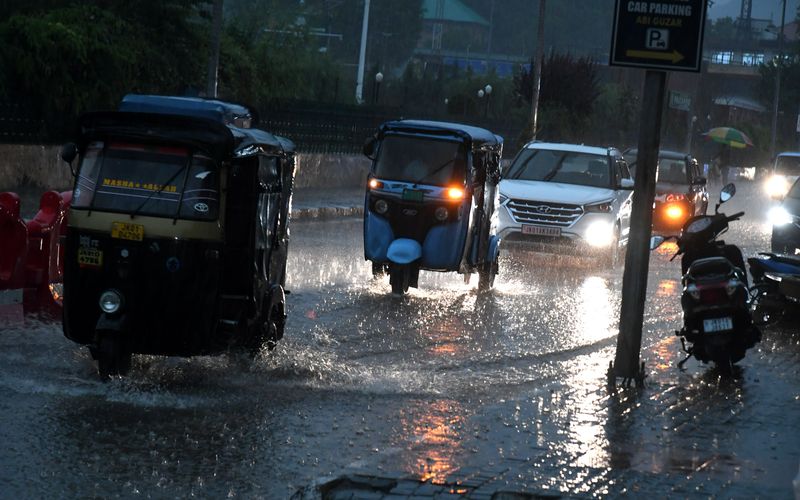
- Wet and slippery roads
- Reduced visibility in mountainous areas
- Temporary disruptions in transport
March 31–April 2: Gradual Improvement
After March 30, the system is expected to weaken.
Conditions
- Skies turning mostly sunny
- Clear nights with cooler temperatures
- Minimal precipitation chances (as low as 8–22%)
This phase offers relief but may also bring colder nights due to post-rain radiative cooling.
April 4: Another Minor Spell
Meteorologists are also tracking a weaker follow-up system around April 4.
- Light rain likely
- Short-lived disturbance
- Minimal disruption expected
Ground Reality Check: How Accurate Is This Forecast?
Forecasts from India Meteorological Department, especially from Meteorological Centre Srinagar, have shown increasing reliability in recent years due to:
- Improved satellite data
- High-resolution numerical weather models
- Better local observation networks
Historically, late-March western disturbances in Kashmir have produced similar patterns:
- Rain in Srinagar and surrounding plains
- Snowfall above 2,000–2,500 meters
- Wind gusts affecting orchards and infrastructure
Ground reports from previous years confirm that such systems often lead to short-term disruptions but are crucial for replenishing water resources.
Impact Analysis: What This Means for Different Sectors
1. Travel & Transport: Delays Likely
Travelers across Jammu & Kashmir should prepare for potential disruptions.
Key Risks
- Slippery roads in higher reaches
- Snow accumulation in mountain passes
- Possible delays on highways
Critical routes like the Srinagar-Leh highway and Mughal Road may experience temporary closures or slowdowns.
Air travel could also face delays due to low visibility and changing wind conditions.
2. Agriculture: A Mixed Blessing
For farmers, this weather spell is both beneficial and risky.
Positive Impacts
- Moisture for crops and orchards
- Improved soil conditions
Risks
- Damage to early blossoms in apple orchards
- Lodging (flattening) of crops due to wind
- Waterlogging in low-lying fields
Farmers are strongly advised to:
- Secure orchard structures
- Protect young plants
- Ensure proper drainage
3. Daily Life: Prepare for Sudden Changes
Residents should be ready for:
- Cooler nights after rainfall
- Sudden wind gusts
- Wet commuting conditions
Carrying rain gear and planning travel ahead can help avoid inconvenience.
Why This Weather Matters: The Bigger Climate Context
Kashmir’s weather is increasingly influenced by shifting climate patterns.
Recent years have seen:
- Irregular snowfall patterns
- Warmer winters
- Sudden, intense weather events
This makes even short weather spells like this one significant.
They:
- Recharge water sources
- Support agriculture
- Maintain ecological balance
But they also highlight the region’s growing vulnerability to climate variability.
Expert Advisory: What You Should Do Now
For Travelers
- Check weather updates before departure
- Avoid night travel in hilly areas during peak disturbance
- Keep buffer time for delays
For Farmers
- Cover sensitive crops
- Strengthen support structures for orchards
- Monitor drainage systems
For Residents
- Keep rain gear handy
- Secure loose outdoor items
- Stay updated with official advisories
Human Angle: Life in Transition
In Kashmir, weather is not just a forecast—it shapes daily life.
A sudden snowfall can turn landscapes magical but also isolate communities. Rain can nourish crops but disrupt livelihoods.
This upcoming spell is another reminder of how closely life in the region is tied to nature’s rhythms.
For many, it’s a time to pause, prepare, and adapt.
Final Takeaway
From the night of March 28, Jammu & Kashmir is set to experience a noticeable shift in weather, with rain, snowfall in higher reaches, and gusty winds dominating the region until March 30.
While the disturbance may bring short-term disruptions, it also plays a vital role in sustaining the region’s ecological and agricultural balance.
As always, awareness and preparation remain the best tools to navigate such changes.