J&K Flood Risk Exposed: 1,017 Vulnerable Locations Put Over 10 Lakh People at Risk as Heavy Rains Continue
By: Javid Amin | 26 July 2026
654 Vulnerable Villages Identified in Kashmir Valley Alone; 1,505 People Already Shifted to Safer Locations
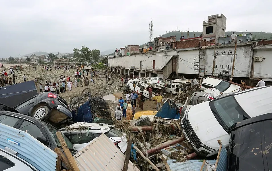
The scale of Jammu and Kashmir’s vulnerability to floods and flash floods has come into sharp focus after authorities identified 1,017 vulnerable locations across the Union Territory, with more than 10 lakh people considered at risk amid persistent rainfall and the threat of rising rivers, flash floods and landslides.
The latest assessment, reviewed during a high-level meeting chaired by Chief Minister Omar Abdullah, provides one of the clearest indications yet of the population potentially exposed to extreme weather emergencies across both the Kashmir Valley and Jammu division.
Of the total, officials identified 654 vulnerable villages in the Kashmir Valley, with an estimated 7.22 lakh people at risk. In the 10 districts of the Jammu division, 363 vulnerable locations have been identified.
The figures come at a particularly sensitive time, with parts of Jammu and Kashmir experiencing heavy rainfall, flash floods and landslides, while river systems including the Jhelum, Chenab and Tawi remain under close observation.
Importantly, the figure of 1,017 refers to identified vulnerable locations, not necessarily locations currently experiencing flooding. Similarly, the 10 lakh-plus population figure represents people considered potentially at risk, rather than residents currently displaced by floods. This distinction is crucial when interpreting the data.
1,017 Vulnerable Locations: What the Numbers Reveal
The latest preparedness assessment divides the vulnerability broadly between the two administrative divisions.
| Area | Vulnerable Locations/Villages | Population at Risk |
|---|---|---|
| Kashmir Valley | 654 vulnerable villages | Approximately 7.22 lakh |
| Jammu Division | 363 vulnerable locations | Population figure not specified in the cited update |
| Jammu & Kashmir Total | 1,017 | More than 10 lakh |
The Kashmir Valley’s 654 vulnerable villages account for a substantial share of the identified risk. Authorities have already shifted 1,505 people from vulnerable areas to designated rescue centres as a precaution, while evacuation plans remain in place elsewhere.
The assessment demonstrates that flood preparedness in J&K is not limited to Srinagar or the banks of the Jhelum. The risk extends across multiple river basins, mountain catchments and low-lying settlements.
Why Kashmir’s Flood Risk Is So Complex
Jammu and Kashmir’s geography makes disaster management particularly challenging.
The Union Territory combines:
- High-altitude mountain catchments.
- Steep slopes prone to landslides.
- Major river systems.
- Numerous seasonal streams and nallahs.
- Densely populated valley floors.
- Expanding urban settlements.
- Remote villages with limited road connectivity.
In the Kashmir Valley, the Jhelum and its tributaries form the central drainage system. In the Jammu region, the Chenab, Tawi and their tributaries create a different but equally complex flood-risk landscape.
A cloudburst or intense rainfall event in an upper catchment can rapidly send water downstream, leaving communities with little time to respond.
This is particularly dangerous in smaller mountain streams, where water levels can rise much faster than in the main river channels.
The 2014 Flood Memory Still Shapes Kashmir’s Anxiety
The latest risk assessment comes against the backdrop of the catastrophic September 2014 floods, which remain the benchmark against which Kashmir’s flood preparedness is judged.
The 2014 disaster inundated large parts of the Kashmir Valley, including extensive areas of Srinagar, and caused major loss of life, homes, crops and infrastructure.
Official government data recorded 282 deaths, while more than 2.53 lakh houses were reported damaged and approximately 6.48 lakh hectares of cropped area was affected.
For residents who lived through that disaster, prolonged rainfall immediately triggers concern.
However, the identification of 1,017 vulnerable locations should not be interpreted as a prediction that another 2014-scale flood is imminent.
Instead, it highlights the potential scale of exposure and the importance of preparedness before an extreme event occurs.
South Kashmir Remains a Critical Flood-Watch Zone
Several parts of South Kashmir are particularly sensitive to heavy rainfall because of their location near major tributaries and mountain catchments.
Areas around:
- Anantnag
- Pulwama
- Kulgam
- Shopian
- Awantipora
- Srinagar’s downstream floodplain
can experience rapidly changing conditions during intense rainfall.
The risk is not limited to the Jhelum itself. Smaller streams can overflow or surge rapidly, causing flash floods and damaging roads, bridges and agricultural land before the main river reaches dangerous levels.
This means residents should not assume that a normal Jhelum reading automatically means there is no local flood danger.
Jammu Region Faces a Different but Equally Serious Risk
The identification of 363 vulnerable locations across the 10 districts of Jammu division underscores the scale of the challenge south of the Pir Panjal.
Districts such as:
- Rajouri
- Poonch
- Doda
- Kishtwar
- Ramban
- Reasi
- Kathua
- Jammu
- Samba
- Udhampur
face varying combinations of flash floods, landslides and river flooding.
Recent extreme-weather incidents in the Pir Panjal region have demonstrated how quickly mountain rainfall can turn into a disaster.
In hilly districts, the greatest threat may come from a combination of landslides, debris flows and flash floods, rather than a slow-rising river alone.
Preparedness Has Intensified, But the Risk Remains
Authorities have substantially expanded emergency preparedness measures.
According to the latest review, the administration has placed:
- 744 rescue centres on standby.
- 108 SDRF boats ready for operations.
- 25 Army boats available for emergency response.
- 98 satellite phones for communication.
- 102 identified helipads for emergency operations.
- Trained volunteers and emergency equipment in readiness.
Officials have also reported that 142 mock drills have been conducted in the Jammu division, while 138 functional helipads have been earmarked for emergency operations there.
District Emergency Operations Centres and the State Emergency Operations Centre are also functioning around the clock to monitor weather conditions and coordinate emergency responses.
These measures indicate a shift from reactive disaster response towards more structured preparedness.
But Long-Term Flood Protection Remains the Bigger Challenge
Emergency response can save lives during a disaster. But it cannot replace long-term flood mitigation.
This is where the debate over J&K’s flood-management projects becomes important.
Post-2014 flood-management programmes were designed to improve the Valley’s ability to handle high flows through measures including:
- Jhelum dredging.
- Embankment strengthening.
- Flood-channel improvements.
- Better drainage capacity.
- Flood forecasting.
- River-basin management.
The reported combined value of major post-2014 projects has been put at around ₹2,021 crore, although recent reporting indicates that key components have faced implementation delays and technical disagreements. The precise status of individual works should be assessed project by project rather than treating the entire programme as “stalled.”
The broader concern is valid, however: every year of delay is a year in which vulnerable communities remain exposed to extreme weather.
Climate Change Is Adding a New Layer of Risk
The flood threat is also evolving because the climate itself is changing.
Across the Himalayan region, scientists have documented growing concern over:
- Intense short-duration rainfall.
- Cloudbursts.
- Erratic precipitation.
- Flash floods.
- Landslides.
- Longer dry periods interrupted by extreme rain.
A warmer atmosphere can hold more moisture, potentially contributing to more intense rainfall when atmospheric conditions trigger precipitation.
But climate change is only one part of the equation.
Risk is also amplified by:
Unplanned Construction
Buildings and infrastructure located too close to rivers, streams and natural drainage channels can increase exposure.
Loss of Natural Flood Buffers
Wetlands and floodplains can absorb excess water, but encroachment reduces their capacity.
Deforestation and Land-Use Changes
Changes in mountain catchments can influence runoff and slope stability.
Urban Expansion
Growing cities create more impermeable surfaces, causing rainwater to run off rapidly rather than infiltrating the ground.
The result is a more complicated disaster-risk environment in which extreme rainfall interacts with human development.
The Economic Cost Could Be Enormous
A major flood in J&K would have consequences far beyond immediate loss of life.
Agriculture
Floods can destroy paddy fields, orchards, vegetable crops and livestock, affecting rural livelihoods.
Tourism
Road closures, damaged hotels and disrupted transport can affect one of the region’s most important economic sectors.
Trade
The Jammu-Srinagar highway and other strategic transport routes are vulnerable to landslides and weather-related closures.
Infrastructure
Bridges, roads, power lines, water-supply systems and telecommunications networks can suffer extensive damage.
Urban Economy
Srinagar’s dense urban areas remain particularly vulnerable to prolonged waterlogging and disruption.
The economic consequences can continue long after floodwaters recede.
The Governance Challenge: From Risk Mapping to Action
The identification of 1,017 vulnerable locations is valuable only if the information translates into concrete action.
The next stage should involve:
Risk-Based Infrastructure Planning
Critical roads, bridges, hospitals and schools in vulnerable areas should be assessed for resilience.
Village-Level Evacuation Plans
Every high-risk settlement should have clearly defined evacuation routes and safe shelters.
Real-Time Early Warning
Residents need warnings that are fast, location-specific and easy to understand.
River-Basin Management
Flood planning should cover the entire catchment, from mountain streams to downstream floodplains.
Protection of Wetlands and Floodplains
Natural water-storage systems should be treated as critical flood infrastructure.
Faster Project Execution
Technical disputes should be resolved through transparent expert review rather than allowing critical mitigation works to remain delayed indefinitely.
What Residents in Vulnerable Areas Should Do
People living near rivers, streams and low-lying areas should not wait for a major flood warning before preparing.
Families can:
- Keep emergency medicines and essential documents ready.
- Store safe drinking water.
- Maintain a basic emergency kit.
- Keep mobile phones and power banks charged.
- Identify the nearest designated rescue centre.
- Monitor official weather and flood alerts.
- Avoid crossing swollen streams or flooded roads.
- Move livestock to safer locations when advised.
- Follow evacuation orders immediately.
During intense rainfall, residents should pay particular attention to local streams and nallahs, which may rise rapidly even when the main river appears stable.
The Real Warning Behind the 1,017 Figure
The most important message from the latest assessment is not that 10 lakh people are currently facing a flood.
It is that more than 10 lakh people live in areas that authorities have identified as potentially vulnerable to flood-related emergencies.
That distinction matters.
It means the government now has a clearer map of where disaster preparedness must be concentrated.
The challenge is to turn that map into action.
For Kashmir, the experience of 2014 demonstrated the devastating consequences of being unprepared for an extreme flood. The recent flash floods and landslides across the Jammu region have shown that the threat is not confined to the Valley.
As rainfall patterns become increasingly unpredictable, flood resilience must become a continuous public policy priority—not a response activated only when rivers begin to rise.
With 1,017 vulnerable locations identified and more than 10 lakh people potentially exposed, the scale of the challenge is clear. The next step is ensuring that early warnings reach every village, evacuation plans work on the ground, infrastructure can withstand extreme weather, and long-delayed mitigation projects move from government files to completed protection on the ground.
Editor’s Fact-Check & Context Note
- The 1,017 vulnerable locations figure and 10 lakh-plus population at risk come from the latest preparedness review cited in recent reporting. The breakdown available from that review identifies 654 vulnerable villages and approximately 7.22 lakh people at risk in Kashmir Division, while 363 vulnerable locations were identified across Jammu Division.
- The 1,017 figure should not be described as 1,017 locations currently under floodwater. It refers to locations identified as vulnerable to flood, flash-flood and related weather hazards.
- The supplied brief names Srinagar, Anantnag, Pulwama, Baramulla, Rajouri and Poonch as key vulnerable districts. The latest preparedness reporting reviewed for this article provides the divisional totals but does not provide a district-wise breakdown of all 1,017 locations, so a precise district-by-district count should not be inferred without an official list.
- The ₹2,021-crore figure relates to major post-2014 flood-management programmes reported in earlier coverage. It should not be presented as proof that the entire flood-management programme is stalled; available reporting indicates that specific components have faced delays and technical issues.
- The latest preparedness measures—including rescue centres, boats, satellite phones and evacuation arrangements—indicate that the administration has significantly strengthened its emergency response capacity.


