Jammu & Kashmir Landslide Hotspots: Why the Himalayas Are Becoming a Bigger Risk to Roads, Villages and Infrastructure
By: Javid Amin | 08 September 2026
From Ramban’s unstable slopes to the deeply dissected valleys of Doda and Kishtwar, landslides are becoming one of Jammu & Kashmir’s most persistent infrastructure and disaster-management challenges. New susceptibility studies show that the risk stretches across a much wider geography than a handful of notorious road sections.
A mountain road can look perfectly normal in the morning and disappear under tonnes of rock and mud by afternoon.
That is the unsettling reality of travelling through Jammu & Kashmir’s young and geologically fragile Himalayan landscape.
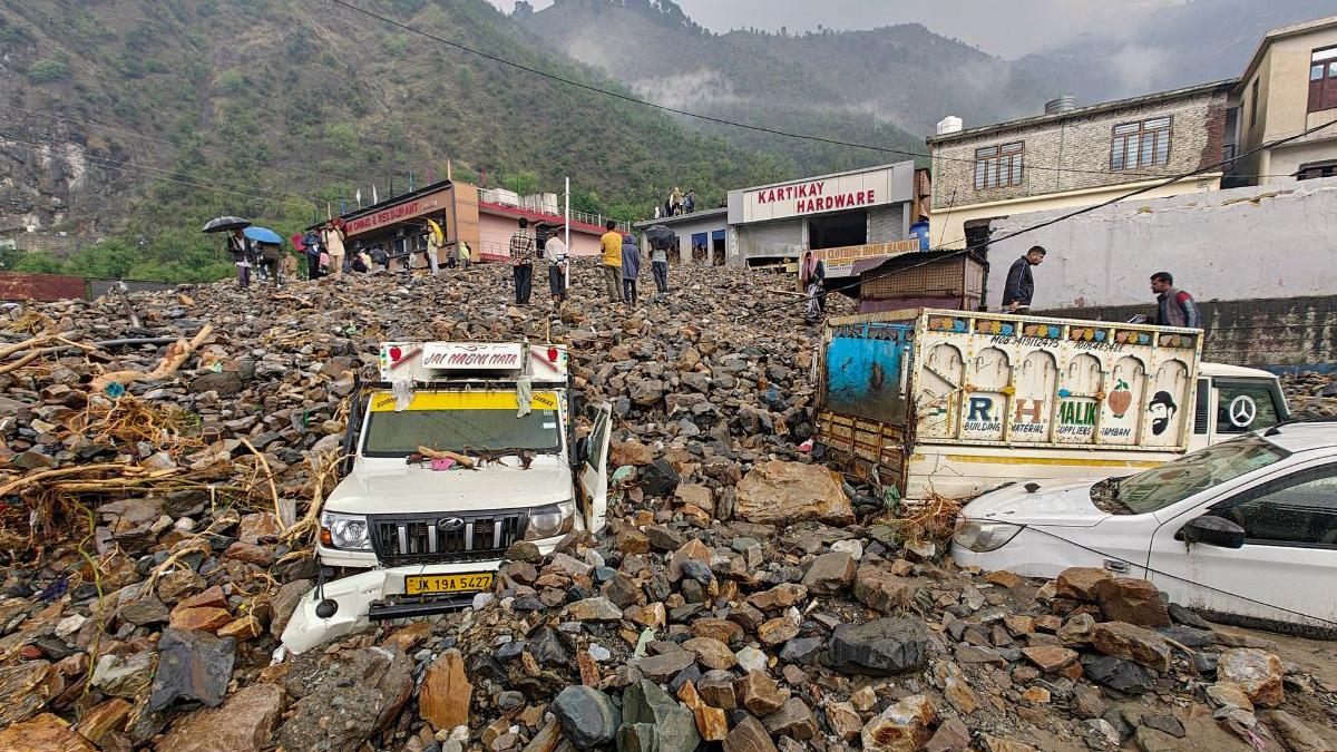
Every monsoon, the same pattern returns: rocks tumble onto highways, slopes give way, streams carry debris across roads and vehicles are stranded for hours. Sometimes the consequences are far worse — homes are damaged, workers are killed, villages are isolated and major transport corridors are forced to close.
The problem is not simply heavy rainfall.
Jammu & Kashmir combines steep slopes, complex geology, seismic activity, river erosion and increasingly intensive road and infrastructure construction. When these natural and human pressures overlap, a relatively short spell of intense rain can destabilise a slope that has been under stress for years.
Recent scientific research has reinforced just how widespread the vulnerability is.
A major 2026 study published in Scientific Reports developed a landslide inventory containing 669 mapped landslide events across approximately 42,950 square kilometres of Jammu & Kashmir. The researchers combined satellite imagery, field observations and GIS-based analysis to classify the terrain into five susceptibility categories. Their assessment placed about 3.65 per cent of the study area in the very-high susceptibility category and 24.43 per cent in the high-susceptibility category.
That does not mean nearly 28 per cent of J&K will experience landslides.
It means a substantial area has physical characteristics associated with higher susceptibility — an important distinction for policymakers, planners and residents.
And it changes the conversation.
The question is no longer where landslides happen.
It is how much development is taking place in landscapes where landslides are already known to be a recurring hazard.
The Ramban-Banihal Corridor: J&K’s Most Visible Landslide Problem
If there is one road section that has become synonymous with landslide disruption in J&K, it is the Ramban-Banihal stretch of National Highway-44.
The corridor passes through some of the most difficult terrain between Jammu and Kashmir. Steep slopes rise immediately above the road in several sections, while the Chenab and its tributaries have cut deeply into the mountains.
Scientific research has specifically described the Ramban-Banihal road section as one of the most landslide-prone areas in the Jammu & Kashmir Himalaya, with frequent landslide occurrences causing infrastructure damage and fatalities.
Another study focusing on the Udhampur-Ramban section identified 84 landsliding sites using field visits and satellite imagery. The researchers found that elevation and terrain ruggedness were among the dominant factors associated with slope instability, followed by slope aspect and land-use/land-cover characteristics.
The engineering challenge is obvious.
Road construction cuts into slopes.
Traffic and widening projects increase the amount of infrastructure occupying narrow mountain corridors.
Water enters fractures and weak layers.
Heavy rainfall raises soil moisture and pore-water pressure.
River erosion removes support at the foot of slopes.
And once a critical threshold is crossed, gravity does the rest.
This is why simply clearing debris after a landslide cannot be considered a complete solution.
The objective has to be to understand which slopes are likely to fail before they fail.
NH-44 Is Getting Safer — But the Risk Has Not Disappeared
There is an important development that should not be overlooked.
The government has been attempting to reduce exposure to some of the most problematic sections of the Jammu-Srinagar highway by constructing tunnels and upgrading the road.
The Chenani-Nashri tunnel, for example, was specifically designed to bypass snow- and landslide-prone sections around Kud, Patnitop and Batote. The Ramban district administration describes the 10.89-km tunnel as a major alternative to some of the vulnerable mountain stretches.
More recently, the Digdol-Panthyal twin-tube tunnel project has been promoted as a way to avoid one of the historically troublesome sections between Ramban and Banihal. The Union Ministry of Road Transport and Highways described the old Digdol-Panthyal stretch as being repeatedly affected by falling rocks, landslides and heavy rainfall.
These projects demonstrate an important principle in Himalayan infrastructure:
Sometimes the best landslide mitigation is not to fight the mountain, but to avoid the unstable slope altogether.
But tunnels cannot solve every problem.
Approach roads, portals, adjoining slopes and alternative routes remain exposed. Nor can tunnels eliminate landslides elsewhere along the highway.
The geography remains.
Chenab Valley: Where Geology Meets Mega Infrastructure
The Chenab Valley presents a different and potentially more complicated form of landslide risk.
The Doda-Kishtwar-Ramban belt is characterised by rugged terrain, deep river valleys and complex geological formations. A 2024 peer-reviewed study specifically modelled landslide susceptibility across these three districts, identifying areas ranging from very high to very low susceptibility. The researchers described the region as particularly vulnerable because of its steep slopes, deep valleys and geological conditions.
GSI has also carried out landslide susceptibility work in the Chenab River basin. Its documentation records macro-scale susceptibility mapping covering parts of the Chenab Valley.
The risk becomes even more consequential because the Chenab region is also an important centre of hydropower development.
Large projects require roads, tunnels, underground caverns, access tracks, transmission infrastructure and extensive slope modification.
That does not mean hydropower construction automatically causes landslides.
It means engineering activity must be carefully designed around the pre-existing geological risk.
The distinction is crucial.
A mountain slope that is naturally unstable can become more vulnerable when excavation changes its geometry, drainage or loading conditions.
The consequences were visible again in July 2026 when intense rainfall triggered flash floods and landslides in the Chenab Valley. At the under-construction 540-MW Kwar Hydroelectric Power Project in Kishtwar, debris entered the project area and buried or damaged construction vehicles, while flooding and debris also blocked sections of the Doda-Kishtwar road.
The event was a reminder that disaster risk assessment cannot stop at the boundary of a construction site.
It must encompass the entire catchment and transportation network around it.
Doda and Kishtwar: The Risk Is Bigger Than Highway Closures
The Doda-Kishtwar region deserves particular attention because landslides here affect more than a single transport corridor.
Settlements are frequently distributed along narrow valleys and mountain roads. Roads often double as lifelines for healthcare, education, food supplies, construction material and emergency services.
A landslide that blocks a road for several hours is an inconvenience.
A closure lasting several days can become a humanitarian problem.
The 2024 Doda-Kishtwar-Ramban susceptibility study was specifically developed to support decision-making by identifying areas where proactive landslide-risk reduction could be prioritised.
The emerging scientific picture therefore favours risk zoning before infrastructure expansion, rather than trying to retrofit every road after repeated failures.
Pir Panjal: A Broad Zone of Concern
The Pir Panjal range adds another layer to J&K’s landslide geography.
Recent research covering the Mirpur-Poonch-Rajouri-Reasi-Udhampur region used remote sensing and GIS-based modelling to identify spatial differences in landslide susceptibility. The researchers emphasised the importance of combining environmental and terrain variables to support mitigation and planning in the region.
A separate 2026 susceptibility assessment identified landslide occurrences across areas including Poonch, Ramban, Doda, Kishtwar, Baramulla, Uri, Anantnag, Ganderbal, Kathua and Reasi, demonstrating that landslide vulnerability is not confined to the Chenab Valley.
This is an important correction to the simplistic idea of a few isolated “hotspots”.
J&K’s landslide problem is better understood as a network of high-susceptibility mountain environments, with particular roads, slopes and settlements becoming especially vulnerable under certain combinations of rainfall, geology, slope geometry and human intervention.
Poonch and Rajouri Show Why Rainfall Can Quickly Become a Disaster
The vulnerability of the Pir Panjal region was dramatically demonstrated during the July 2026 extreme-weather episode in Poonch and Rajouri.
Heavy overnight rain triggered flash flooding and landslides, killing people and damaging homes and infrastructure. Reports from the event highlighted severe impacts in Poonch and Rajouri, while authorities mobilised rescue and relief operations.
The lesson extends beyond those districts.
Flash floods and landslides often arrive together because intense rainfall can simultaneously saturate slopes and rapidly increase runoff.
This creates a dangerous feedback:
Rain → slope saturation → landslide → blocked stream/drainage channel → sudden debris flow or flooding.
That is why treating landslides and floods as completely separate disasters can leave a major gap in preparedness.
What About Kupwara and Baramulla?
The original hotspot list identifies Kupwara and Baramulla as landslide-risk areas, but the claim that their vulnerability can simply be attributed to “glacial retreat” is too broad.
There is evidence of landslide and debris-slide activity in northern Kashmir, including Baramulla and Uri. The 2026 Scientific Reports study recorded field-validated landslide/debris-flow examples around Baramulla and Uri.
But landslide susceptibility is controlled by a combination of factors — including geology, slope, drainage, land cover, elevation, rainfall and proximity to roads or streams.
Glacier retreat is an important Himalayan environmental concern, but it should not be presented as the direct explanation for every landslide in Kupwara or Baramulla.
That distinction is especially important in environmental journalism.
Climate change can alter the background conditions under which hazards occur; it does not provide a simple explanation for every individual landslide.
Climate Change Is Adding Uncertainty to an Already Fragile Landscape
Climate change is becoming an important part of the landslide discussion, but again, the relationship is not as simple as “warming equals more landslides.”
Heavy rainfall is one of the most important immediate triggers for many landslides.
When rainfall intensity increases, water can infiltrate slopes, raise pore-water pressure and reduce effective strength in susceptible materials. In steep Himalayan terrain, that can destabilise slopes already weakened by geological structures, erosion or excavation.
At the same time, glacier retreat and changes in snow and precipitation patterns can alter mountain hydrology.
The broader concern is therefore not just an increase in one particular hazard.
It is greater variability and uncertainty in the natural systems on which infrastructure planning has historically depended.
That makes long-term landslide monitoring increasingly important.
The Human Factor: Roads Can Increase Exposure
One of the most important findings emerging from recent research is the relationship between infrastructure and slope instability.
The 2026 Scientific Reports study incorporated proximity to roads and streams, geology, geomorphology, slope, elevation and land-use/land-cover into its susceptibility model. The authors also highlighted road construction and infrastructure development as important contributors to landslide occurrence where slopes are modified in structurally weak areas.
This does not mean roads should not be built.
J&K needs roads.
Mountain communities need connectivity. Hospitals need access. Tourism depends on transport. Hydropower projects require infrastructure. Remote villages cannot be left isolated.
The real question is how roads are designed and where they are cut.
Poorly designed drainage can allow water to enter a slope.
Uncontrolled disposal of excavated material can overload or obstruct natural channels.
Cutting the toe of a slope can remove supporting material.
Unprotected rock faces can weather and fracture.
A road may therefore become both a lifeline and a potential contributor to slope instability.
The “1,000 Hotspots” Figure Needs a More Careful Explanation
One claim frequently repeated in discussions about J&K’s landslide risk is that GSI and NIDM have identified more than 1,000 landslide-prone zones.
The underlying point — that J&K has a very large number of landslide-prone locations and has been extensively studied — is credible.
But the 1,000 figure should not be presented as a single official GSI/NIDM count of “hotspots” unless a specific government document and methodology are cited.
GSI’s current national landslide platform maintains state-level inventories, susceptibility products and field-validated landslide information.
ISRO’s Landslide Atlas of India, meanwhile, contains a national geospatial inventory of approximately 80,000 landslides mapped during 1998-2022 across vulnerable regions, including Jammu & Kashmir. Its database includes seasonal, event-based and route-wise inventories.
Those are inventories of mapped landslides, not necessarily 80,000 separate permanent “hotspots”.
That distinction should be retained in any serious news report.
The newer scientific studies are actually more useful for understanding present risk because they combine historical landslide inventories with terrain and environmental variables to produce susceptibility maps.
What J&K Needs Now: From Debris Clearance to Slope Management
For years, the familiar response to a landslide has been straightforward:
Clear the road.
Restore traffic.
Repair the damaged infrastructure.
Wait for the next event.
That approach is unavoidable during an emergency, but it cannot be the entire strategy.
J&K needs a more systematic slope-management programme.
1. Map slopes before approving projects
Every major road, tunnel, hydropower and urban-development project in mountainous terrain should be assessed against updated landslide susceptibility maps.
2. Build drainage into slope engineering
Water is often the trigger that turns instability into failure. Surface drains, subsurface drainage and properly maintained culverts should therefore be treated as core slope-stabilisation infrastructure.
3. Monitor known unstable slopes
Remote sensing, ground instruments, rainfall thresholds and field inspections can help identify changing conditions before catastrophic failure.
4. Strengthen early-warning systems
Landslide warning cannot simply mean a generic “heavy rain” alert. Where scientifically feasible, rainfall thresholds should be linked to known susceptible slopes and road corridors.
5. Stop treating debris clearance as mitigation
Removing debris restores connectivity. It does not necessarily make the slope safe.
6. Protect natural drainage and vegetation
Vegetation cannot prevent every landslide, but land-cover management, erosion control and protection of natural drainage systems can reduce some forms of slope degradation.
7. Make road agencies accountable for slope safety
A mountain road should be judged not only by kilometres constructed, but also by its drainage performance, slope stability, maintenance and disaster history.
A Road Can Be a Lifeline — Until the Mountain Comes Down
For Kashmir, the consequences of landslides extend far beyond blocked roads.
The Jammu-Srinagar corridor connects people, food, medicines, fuel, construction materials and commercial goods.
Tourism depends on predictable connectivity.
Farmers need markets.
Hospitals need supplies.
Families need access to schools and workplaces.
That makes landslide management an economic issue as much as a geological one.
The same is true in Doda, Kishtwar, Ramban, Poonch, Rajouri and other mountain districts, where a single road closure can isolate communities that have few alternative routes.
The real cost of a landslide therefore cannot be calculated simply from the value of damaged asphalt.
It includes lost working days, delayed medical care, stranded travellers, disrupted supply chains, cancelled tourism bookings and the long-term economic insecurity of communities living beside unstable slopes.
The Next Step Is Not to Fight Every Landslide — It Is to Reduce Exposure
Landslides are a natural part of Himalayan geomorphology.
They cannot be eliminated.
The goal of disaster management is therefore not to create a mountain landscape where slopes never fail.
It is to ensure that when a slope fails, people are not beneath it, critical infrastructure is not unnecessarily exposed and alternative routes and emergency systems are ready.
That requires better science, but science alone will not be enough.
The findings already available from GSI, ISRO, universities and other research institutions provide increasingly detailed information about where the ground is more likely to become unstable.
The next challenge is governance.
Do susceptibility maps influence where roads are built?
Are vulnerable slopes monitored continuously?
Are drainage systems maintained before the monsoon?
Are communities told which roads or slopes should be avoided during extreme rainfall?
Are construction agencies required to account for cumulative slope impacts?
And when a landslide happens repeatedly at the same location, why is the response still temporary?
These questions will determine whether J&K’s growing body of geological knowledge becomes a practical disaster-management tool — or remains another collection of maps on government and academic servers.
Jammu & Kashmir’s Landslide Risk Is a Planning Problem as Much as a Geological One
The Himalayas are not standing still.
Nor is Jammu & Kashmir.
Roads are expanding. Towns are growing. Hydropower infrastructure is increasing. Tourism is pushing development into previously less accessible areas. Climate patterns are changing.
Against this backdrop, landslide susceptibility should become a routine consideration in every major mountain development decision.
The Ramban-Banihal corridor, Doda-Kishtwar-Ramban belt, Pir Panjal districts, and vulnerable sections of the northern Kashmir landscape are not identical hazards. Each has its own geology, hydrology, infrastructure pressures and settlement patterns.
That means J&K needs something more sophisticated than a single list of “landslide hotspots”.
It needs district-level risk maps, corridor-specific monitoring, project-level geological assessment, reliable early warnings and community evacuation plans.
The science is increasingly capable of telling us where the ground is vulnerable.
The harder task is acting on that information before gravity, rain and geology make the decision for us.
For Jammu & Kashmir, that is the real landslide warning — not that every mountain is about to collapse, but that every new road, tunnel, building and project needs to be designed with the mountain’s limits in mind.


