68 Glacial Lakes Under Watch in J&K: Why Kashmir Is Preparing for GLOF Risk
By: Javid Amin | 28 September 2026
Srinagar: High above the valleys of Jammu and Kashmir, where glaciers feed streams and rivers that eventually reach settlements far below, a new layer of risk is taking shape.
The Jammu and Kashmir government has identified 68 potentially dangerous glacial lakes across the Union Territory and is preparing a real-time early-warning system designed to detect dangerous changes before a Glacial Lake Outburst Flood, or GLOF, reaches downstream communities.
The disclosure came in the J&K Legislative Assembly in response to a question by MLA Tanvir Sadiq. According to the government response, the University of Kashmir has mapped 616 glacial lakes across 12 districts, covering a combined area of 28.62 square kilometres. Of these, 68 have been classified as Potentially Dangerous Glacial Lakes under criteria prescribed by the National Disaster Management Authority.
The numbers are significant, but the more important story is what lies behind them. Kashmir’s glaciers and high-altitude lakes are not static features. They are changing with the climate, and scientists increasingly view the combination of glacier retreat, expanding lakes, unstable terrain and extreme weather as a growing disaster-management challenge.
For J&K, the question is no longer simply how many glacial lakes exist. It is how quickly authorities can understand what is happening at the most vulnerable ones, communicate that information downstream and give people enough time to move out of harm’s way.
A large inventory, but not 616 immediate threats
The first point that needs explaining is the difference between inventory and hazard.
The government’s figure of 616 lakes does not mean that 616 lakes are on the verge of bursting.
It represents the broader inventory identified by the University of Kashmir. Within that inventory, 68 were classified as potentially dangerous according to the criteria being applied by the authorities.
A separate National Remote Sensing Centre inventory has mapped 546 glacial lakes measuring 0.25 hectares or more in J&K. The difference illustrates why lake counts from different agencies should not simply be added together or treated as competing figures. Remote-sensing inventories can use different minimum-size thresholds, observation periods, classification methods and definitions of what constitutes a glacial lake.
The government’s own response goes a step further. Of the lakes requiring greater attention, 24 high-priority lakes were placed into Category A, B and C classifications after assessment against 17 risk parameters.
That distinction matters because GLOF risk is not determined by lake size alone.
The stability of the natural dam, the slope around the lake, the presence of glaciers or unstable slopes upstream, seismic conditions, the possibility of rock or ice avalanches, lake expansion and the existence of other lakes downstream can all influence the consequences of a potential outburst.
In other words, a large lake is not automatically the most dangerous lake, and a smaller lake cannot automatically be dismissed.
What exactly is a GLOF?
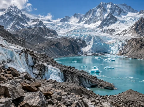
A glacial lake can form as a glacier retreats and leaves behind a depression where meltwater accumulates. In many Himalayan environments, the water may be held back by a natural barrier made from glacial debris, known as a moraine, or by ice and other geological material.
Under ordinary conditions, the lake remains contained.
The danger arises when that natural barrier is destabilised or overtopped.
An avalanche, landslide, sudden rainfall, rapid snowmelt, ice collapse, seismic disturbance or progressive weakening of the moraine can push water over or through the natural dam. Once the barrier fails, a large volume of water can move downstream in a very short period.
The resulting flood is not simply a wave of water.
It can carry boulders, loose sediment, trees, ice and debris, increasing its destructive force as it moves through narrow mountain valleys.
The International Centre for Integrated Mountain Development describes GLOFs as a persistent threat to downstream communities and infrastructure across the Hindu Kush Himalaya. The IPCC has likewise found that glacier retreat and the formation or expansion of glacial lakes are increasing the conditions associated with GLOF risk in high mountain regions.
But there is another important scientific caveat. More glacial lakes and larger lake areas do not automatically mean that GLOF events will occur more frequently everywhere. The hazard depends on local geomorphology, lake and dam characteristics and possible triggers.
That is why monitoring individual lakes matters so much.
Kashmir already has scientific evidence of the danger
The latest government disclosure comes against a growing body of research focused specifically on the Kashmir Himalaya.
A study published in the Journal of Glaciology in January 2026 analysed 155 glacial lakes in the Kashmir Himalaya using satellite observations from 1992 to 2024.
Researchers found that ice-contact proglacial lakes had expanded by 26 per cent over the 32-year observation period. Their assessment identified five lakes as having very high GLOF susceptibility: Bramsar, Chirsar, Nundkol, Gangabal and Bhagsar.
The researchers also examined what could lie downstream if an outburst occurred.
Their modelling indicates that potential GLOF events from the most susceptible lakes could affect several thousand buildings, 15 major bridges, roads and a hydroelectric power project.
That does not mean those structures are currently facing an imminent flood. Rather, the study identifies them as potentially exposed under specific outburst scenarios.
This distinction is crucial for public understanding.
Risk assessment is about preparing for what could happen under defined conditions, not announcing that a disaster is about to happen.
Gangabal shows why one lake can tell a much larger story
Among the lakes repeatedly appearing in scientific assessments is Gangabal, located in the Upper Jhelum Basin.
Earlier research published in Remote Sensing examined Gangabal and its feeding Harmukh glacier using satellite imagery, glacier measurements and hydrodynamic modelling.
That research found that Gangabal’s surface area increased from about 1.42 square kilometres in 1972 to 1.66 square kilometres in 2020, an increase of roughly 17 per cent. Over the same broad period, the Harmukh glacier feeding the lake showed substantial retreat and ice loss.
The researchers modelled hypothetical outburst scenarios and found that a severe breach could produce very large downstream flows, with the flood wave potentially reaching the Naranaag area rapidly.
These are modelling results, not predictions of an actual future flood. Their importance lies elsewhere: they demonstrate how quickly a high-altitude event can become a downstream disaster.
Gangabal is also an example of why authorities cannot look at a lake in isolation. Nundkol lies downstream, creating the possibility of a cascading process in which one lake-related event could affect another water body.
The newer 2026 Kashmir Himalaya study similarly warns that process chains involving multiple lakes can amplify GLOF consequences.
Why Kashmir needs monitoring before the water starts moving
The proposed J&K early-warning system is intended to shift disaster management from periodic observation to continuous monitoring.
The government has nominated the Centre for Development of Advanced Computing, or C-DAC, as the lead technical agency for designing and implementing an indigenous GIS-based GLOF Early Warning System. A formal Memorandum of Agreement is under process.
The proposed architecture is significant because it combines several technologies rather than relying on one warning indicator.
Water-level sensors
Sensor buoys would monitor changes in lake water levels and transmit information through satellite communication.
Sudden or unusual changes in water levels can provide an early indication that conditions are changing.
Automatic weather stations
Weather stations would provide real-time information on temperature, precipitation and other meteorological conditions.
That matters because weather can act as a trigger. Heavy precipitation, rapid warming and accelerated snow or ice melt can alter conditions around vulnerable lakes.
Camera and deformation monitoring
The proposed Glacial Lake Vision Units would use cameras and deformation-detection equipment to observe changes around the lake.
This is particularly important in remote areas where physical access is difficult and dangerous.
A camera cannot replace scientific field assessment, but continuous imagery can provide valuable evidence of changes between expeditions.
GIS and spatial decision support
The information from these different sources would feed into a web portal and Spatial Decision Support System.
This could allow officials to see where a lake is located, what its current conditions are, which downstream areas could be exposed and what warning or evacuation measures may be required.
The ultimate test, however, will not be the sophistication of the dashboard.
It will be whether information reaches the people who need it in time.
The last kilometre may be harder than the technology
An early-warning system is only useful if a warning can travel from a sensor on a remote mountain lake to a village downstream.
That means the J&K programme has two very different challenges.
The first is technological: reliable sensors, communications, power supply, satellite links, data processing and maintenance in extreme terrain.
The second is social and administrative: evacuation routes, warning protocols, local volunteers, mock drills, public awareness and clear responsibility between agencies.
The government’s response indicates that district authorities have been directed to prepare GLOF action plans, identify vulnerable downstream settlements and critical infrastructure, establish safe evacuation locations and conduct mock drills involving disaster-response agencies and local communities.
The administration has also discussed using Aapda Mitras, SDRF, NDRF, ITBP, Civil Defence and local communities in preparedness and emergency response.
This is important because a GLOF does not respect administrative boundaries.
The lake may be located in a remote mountain zone, while the people at risk could live kilometres downstream in another administrative area.
The warning system has been in the pipeline for some time
The September 2026 announcement is therefore not the beginning of J&K’s GLOF preparedness effort.
A Focused GLOF Monitoring Committee was constituted in 2024 under the chairmanship of the Principal Secretary, Home Department.
According to the government’s response, the committee has held five meetings. Earlier decisions included satellite surveillance, field expeditions, standardised lake categorisation, downstream hazard and vulnerability assessments, district-level action plans and community awareness.
The administration has also considered aerial and high-resolution reconnaissance of sensitive areas, including routes associated with the Amarnath Yatra, where GLOFs, landslides and avalanches could create overlapping hazards.
The challenge now is implementation.
A warning system that remains at the proposal or procurement stage does not reduce physical risk on the ground. The effectiveness of the programme will ultimately depend on how quickly equipment is installed, how frequently it is maintained, whether data are interpreted correctly and whether warnings trigger a rehearsed response.
Climate change is changing the background conditions
There is a wider environmental story behind these developments.
The Hindu Kush Himalaya is warming, glaciers are losing mass and many glacial lakes are expanding.
ICIMOD’s 2026 glacier assessment reported that glacier ice loss across the Hindu Kush Himalaya has accelerated, with the rate of ice loss since 2000 roughly double that of the preceding period. The organisation has also stressed that major gaps remain in glacier monitoring across the region.
For Kashmir, that monitoring gap is particularly relevant.
A glacier does not retreat in a neat, predictable line. Its behaviour can vary according to elevation, exposure, snowfall, temperature, debris cover and local topography.
Likewise, a glacial lake can change shape and volume over time.
That means a risk map produced today should not be treated as a permanent document. It needs to be updated.
The 2026 Kashmir Himalaya study itself relied on multi-temporal satellite imagery precisely because change over time is one of the critical variables in understanding GLOF susceptibility.
What happens below the mountains matters just as much
The most important part of GLOF preparedness may ultimately be several kilometres away from the lake itself.
A high-altitude lake can be difficult to reach. But the valley below contains roads, bridges, power infrastructure, tourist facilities, villages, schools, farms and homes.
A flood travelling through a confined mountain valley can gain destructive energy while carrying sediment and debris.
This creates a planning problem that extends beyond disaster management.
Road construction, hydropower projects, tourism infrastructure and settlements in downstream corridors all need to account for changing hazard profiles.
The answer is not simply to stop development in the mountains. It is to make sure that development decisions are informed by the latest hazard maps and that critical infrastructure is not placed in areas where a known extreme event could have catastrophic consequences.
The same principle applies to tourism.
Kashmir’s high-altitude lakes are among its most recognisable landscapes, drawing trekkers, pilgrims, tourists and local communities.
The environmental value of these places is considerable. So is their vulnerability.
The real measure of preparedness will be time
For authorities, the most valuable commodity during a GLOF emergency will not be water-level data, satellite imagery or even sophisticated modelling.
It will be time.
Ten minutes can matter.
Thirty minutes can matter.
An hour can matter enormously in a mountain valley.
But generating that time requires the entire chain to work: the sensor must detect the change, the communication network must transmit it, the system must interpret it, officials must verify the threat, the warning must reach the downstream population and people must know exactly where to go.
That is why the government’s proposed network needs to be viewed as more than a technology project.
It is a disaster-response system.
And disaster-response systems are tested not when everything is functioning normally, but when roads are blocked, communications fail, weather deteriorates and people have only minutes to react.
From mapping lakes to mapping lives
The 68 potentially dangerous lakes identified by J&K are therefore only one part of the story.
The more difficult task is connecting those lakes to the people, infrastructure and ecosystems downstream.
Which villages are directly exposed?
Which bridges could be cut off?
Which roads would become inaccessible?
Which schools, health centres and power installations lie along potential flow paths?
How quickly could residents receive an alert?
Where would they evacuate?
Would mobile networks work during a severe flood?
Who has authority to order evacuation?
These are the questions that transform a scientific hazard assessment into a functioning disaster-preparedness plan.
J&K has already begun moving in that direction through lake inventories, risk classification, scientific studies, field expeditions and plans for a real-time monitoring network.
The next stage is turning those plans into an operational system.
The mountains are changing slowly enough that the change can sometimes be missed from the valley floor. But a GLOF, if triggered, would not move slowly.
That is the central lesson behind the government’s decision to monitor 68 potentially dangerous glacial lakes.
The objective is not to predict a disaster that may or may not happen.
It is to make sure that if the warning signs appear, Kashmir is not seeing them for the first time when the flood is already moving downstream.