Nepal Flood Disaster: 133 Indians Missing as Kashmir’s 5 Glacial Lakes Ring Alarm Bells
By: Javid Amin | 27 August 2026
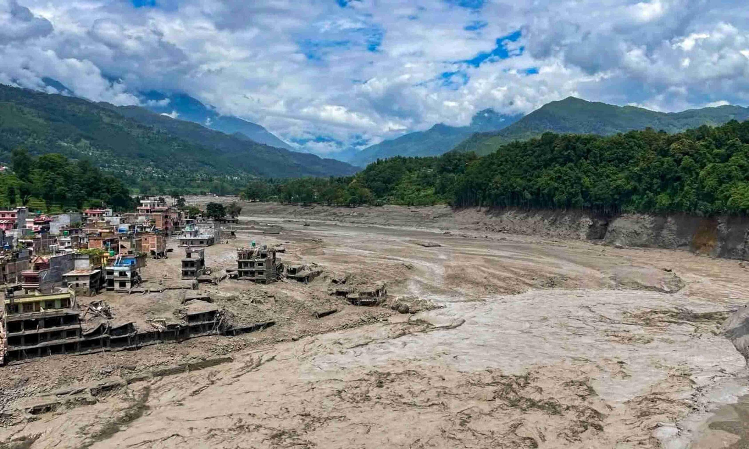
There is a particular kind of horror in a river that arrives without rain. On the morning of August 26, 2026, residents of Timure and Syabrubesi — small border towns tucked into Nepal’s Rasuwa district, where the Bhotekoshi River crosses in from Tibet — had no storm clouds to warn them. What they got instead was a wall. Around 9 a.m., a surge of water, ice and debris came thundering down the valley, having built up somewhere far upstream where a glacier or a blocked river channel had finally, catastrophically, let go. Within minutes, it had swallowed a market, an EV charging station, a customs yard, and a bridge that had linked two nations for generations.
By the time the water reached Kathmandu’s newsrooms as a story, it had already become a tragedy of staggering scale. As of this week, Nepal’s government has confirmed at least 160 deaths, with 403 people still reported missing — including 341 foreign nationals, the single largest group of whom, 133 people, are Indian citizens, many of them pilgrims making the sacred, high-altitude journey to Mount Kailash in Tibet. It is one of the deadliest disasters to strike the Himalayan nation in years, and it has done something else, too: it has forced Jammu and Kashmir, more than a thousand kilometres to the west, to confront an uncomfortable question about its own mountains. Because five of Kashmir’s own glacial lakes carry the same “very high” risk rating that just failed a valley in Nepal.
What Actually Happened in Nepal
A river that turned into a weapon. Investigators are still piecing together the precise trigger, but the emerging picture points to a catastrophic event far upstream on the Tibetan side of the border — most likely an ice avalanche that dammed a tributary of the Bhotekoshi River, the Nepali government’s early assessments suggest, creating a temporary debris lake that then burst with little warning. Nepal’s foreign ministry has also pointed to a possible earthquake-triggered landslide as a contributing factor in blocking the river before it broke free. Whatever the precise sequence, the result was identical to a dam failure: an enormous, sudden pulse of water racing downhill with nothing to slow it down.
The damage, town by town. The flood tore through roughly a dozen settlements strung along the Bhotekoshi and Trishuli rivers — Syabrubesi, Betrawati, Mailung, Salletar, Shantibazar, Pairebesi, Khalti Basti, Sole, Trishuli and Battar among them, with Syabrubesi’s market area among the hardest hit. The Miteri (Friendship) Bridge connecting Nepal and China was swept away entirely. Police posts in Timure, Syabrubesi and Rasuwagadhi were damaged, crippling local communications right when they were needed most. Around 60 houses near Trishuli Bazar in neighbouring Nuwakot district were reportedly destroyed, and floodwaters pushed downstream into parts of Dhading as well, prompting authorities to warn communities along the Trishuli’s entire course to stay off the riverbanks. In total, at least 19 bridges and nearly 40 kilometres of road were washed away or rendered impassable, while Nepal’s electricity authority confirmed damage to six major hydropower and transmission facilities — including the Rasuwagadhi, Chilime, Trishuli 3A and Devighat plants — plunging the disaster response into a fight against darkness as well as debris.
A rescue effort racing the terrain itself. The scale of the response has been enormous: the Nepali Army, Armed Police Force and Nepal Police, backed by helicopters, medical teams and Red Cross volunteers, have been combing the region for survivors. Even reaching the worst-hit areas has proven brutally difficult — one rescue helicopter dispatched to Timure had to turn back without landing after floodwaters swept away the village’s helipad entirely, with the pilot later saying the settlement was barely visible from the air. Despite the odds, the Nepal Army has reported rescuing at least 95 people from the Timure area alone, pulling seven workers trapped inside a hydropower project tunnel in Haku to safety, and safely recovering 21 of the missing Indian tourists. Dozens of security personnel — soldiers, police officers and customs officials posted along the border — were themselves cut off and unaccounted for in the disaster’s immediate aftermath.
The human weight of “missing.” Behind the topline numbers sits a very specific kind of anguish. Many of the 133 missing Indians were partway through the Kailash Mansarovar Yatra, a pilgrimage that draws devout Hindus along remote high-altitude routes through Rasuwa each summer — a journey undertaken, for many, once in a lifetime. At least 50 of the missing Indians are believed to have been on that pilgrimage circuit specifically. India has placed two northern states on flood alert as swollen waters from Nepal head toward the border, while families thousands of kilometres away wait by phones for news that, days on, still hasn’t come for many of them.
Why This Story Belongs to Kashmir Too
It would be easy to read Nepal’s tragedy as a distant catastrophe — devastating, but geographically separate from Jammu and Kashmir’s own monsoon troubles. That read would be a mistake. What happened on the Bhotekoshi is a textbook glacial lake outburst flood, or GLOF — and Kashmir’s mountains harbour lakes that scientists have already flagged as carrying comparable danger.
A quiet warning, delivered months ago. Back in March 2026, in a reply to a question raised in the Jammu and Kashmir Legislative Assembly by National Conference MLA Tanvir Sadiq, Chief Minister Omar Abdullah confirmed something researchers had been quietly documenting: five glacial lakes in the Kashmir Himalaya — Bramsar, Chirsar, Nundkol, Gangabal and Bhagsar — had been classified under the “very high susceptibility” category for potential outburst floods. The finding came from a study conducted by the Department of Geoinformatics at the University of Kashmir, published in the peer-reviewed Journal of Glaciology, which assessed 155 glacial lakes across the region using indicators like lake expansion rate, dam stability and surrounding terrain conditions.
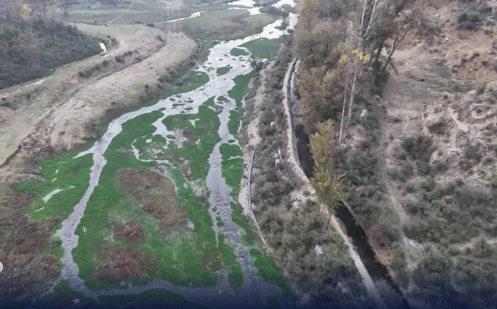
Two lakes, one mountain, thousands at risk. Among the five, Gangabal and Nundkol have drawn particular attention. Fed by glaciers beneath the towering, 16,870-foot Harmukh peak in Ganderbal district, both lakes drain into the Wangath Nullah before joining the Sindh River — a waterway that, further downstream, sustains villages, farmland and infrastructure across a wide stretch of central Kashmir. Researchers estimate that a flood originating from Nundkol alone could affect 1,184 buildings, four bridges and a hydropower plant. Across all five high-risk lakes combined, the potential downstream exposure climbs to roughly 2,700 buildings and 15 major bridges, spread across Ganderbal, Shopian and Kulgam districts — a preliminary geospatial mapping exercise that officials say is only the first step toward understanding the true scale of the threat.
“Not immediate” is not the same as “not real.” To his credit, Chief Minister Abdullah was careful to frame the finding responsibly: a “very high susceptibility” classification does not mean these lakes are on the verge of bursting tomorrow. It means that, relative to other glacial lakes in the region, they possess the structural and environmental characteristics — unstable moraine dams, rapid expansion, exposure to seismic activity or intense rainfall — that make a future outburst significantly more plausible than at most other high-altitude lakes. It’s a distinction that matters, but one that shepherds and villagers living downstream of Gangabal and Nundkol say hasn’t been meaningfully communicated to them. Reporting on the ground has found that many residents in the shadow of these lakes have received no official early-warning information, no evacuation guidance, and nothing translated into local languages — leaving them to rely, essentially, on generations of oral familiarity with terrain that is now changing faster than that familiarity can keep pace with.
The data gap nobody can ignore. Perhaps most tellingly, the University of Kashmir researchers themselves have flagged a critical limitation in their own findings: accurately predicting a GLOF’s magnitude, speed and warning time requires precise knowledge of a lake’s actual volume — data that can only come from field-based bathymetric surveys, essentially underwater topographic mapping. For most Himalayan lakes, including Kashmir’s, that data simply doesn’t exist yet. Work has reportedly begun to close the gap; researchers have procured a high-precision, RTK-enabled robotic echo-sounding boat, funded with support from the Ministry of Earth Sciences, to begin surveying these lakes properly. But surveying takes time, funding and sustained political will — three things that are historically in short supply until after a disaster, not before one.
Nepal’s Wider Ledger of Risk — and What It Says About the Region
Nepal’s own scientific community isn’t waiting for another Bhotekoshi-style tragedy to sound the alarm. In a fresh assessment released this week — timed, pointedly, in the immediate aftermath of the disaster — the International Centre for Integrated Mountain Development (ICIMOD), working with the Government of Nepal, confirmed that 47 lakes across the Koshi, Gandaki and Karnali river basins are classified as Potentially Dangerous Glacial Lakes: 21 within Nepal itself, and 25 sitting just across the border in Tibet, feeding rivers that flow directly into Nepali territory regardless of where the political boundary runs.
Among the most closely watched are Tsho Rolpa in the Rolwaling Valley — one of the largest and longest-studied glacial lakes in the country — along with Imja Tsho near Everest and Thulagi Lake in the Manang region, all of which have expanded significantly as glaciers retreat under sustained warming. Notably, both Tsho Rolpa and Imja Tsho have already had their water levels artificially lowered in past mitigation efforts, precisely because the danger they posed was considered too severe to leave unaddressed — a rare example of proactive intervention that experts say needs to become the rule across the Himalayas, not the exception. The most exposed Nepali districts include Solukhumbu, Sankhuwasabha, Dolakha and Sindhupalchok, alongside downstream communities in Ramechhap, Kavrepalanchok, and — grimly, given the week’s events — Rasuwa itself.
The parallel with Kashmir is impossible to miss: both regions have identified a small, specific set of high-danger lakes through credible scientific assessment; both face the same core drivers — accelerating glacier retreat, unstable moraine dams, and a warming atmosphere loading these systems with more meltwater year on year; and both are still grappling with the same fundamental shortfall — monitoring and early-warning infrastructure that lags meaningfully behind the pace of the risk itself.
The Bigger Climate Picture
None of this is happening in isolation from the broader story of a warming Himalaya. Rising temperatures are accelerating glacier melt across the entire Hindu Kush Himalayan range, swelling the volume of water held behind naturally unstable moraine dams — loose accumulations of rock and sediment that were never engineered to hold back a lake, let alone a growing one. As these lakes expand, the pressure on their dams increases, while the same warming trend also brings more erratic, intense rainfall and a higher chance of triggering events like landslides or avalanches that can breach a fragile dam in moments. It’s the same physics driving the cloudburst crisis that has battered Jammu and Kashmir’s own monsoon this season — different mechanism, same root cause, same mountain range groaning under the weight of a changing climate.
What Needs to Happen Next
Disaster and climate experts studying both the Nepal tragedy and Kashmir’s own risk profile point to a consistent set of priorities that regional governments have, so far, only partially acted on:
- Village-level early warning systems — not just district-wide weather alerts, but localised sirens, sensors and communication networks capable of giving downstream communities minutes, not zero, notice before a lake breaches.
- Bathymetric surveys of high-risk lakes — closing the data gap that currently prevents scientists from accurately modelling how a GLOF from Gangabal, Nundkol or any of Kashmir’s flagged lakes would actually behave.
- Cross-border coordination between India, Nepal and China — since a meaningful share of the most dangerous lakes threatening downstream communities sit on the far side of an international boundary, making unilateral monitoring inherently incomplete.
- Evacuation planning and community drills, delivered in local languages, for every settlement mapped as lying within a high-risk lake’s potential flood path — not as a bureaucratic exercise, but as lived, rehearsed knowledge.
- Restrained development in flood-exposed corridors, recognising that every hotel, bridge or settlement built directly in a glacial river’s path is one more thing standing in the way of water that, sooner or later, is coming.
The Takeaway
Nepal’s flash flood is, first and foremost, a human tragedy still unfolding — 160 confirmed dead, hundreds still missing, and 133 Indian families waiting for news that may never bring relief. But it is also something else: a stress test that an entire mountain range just failed, in real time, on camera. Jammu and Kashmir didn’t need Nepal’s disaster to know its own glacial lakes carried risk — the University of Kashmir study said as much five months ago. What Nepal’s catastrophe has done is strip away any comfort that “very high susceptibility” was an abstract, distant classification. It is, instead, a description of exactly the kind of morning Timure and Syabrubesi just lived through — and a warning that Gangabal, Nundkol and the villages beneath them are, by the region’s own scientific assessment, not so very different.